The Northern Neck Waterfront Locator


”About
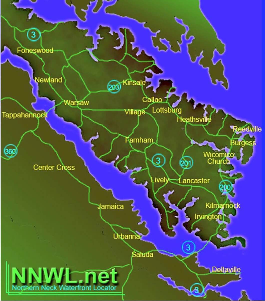
Hello, my name is K. C. Troise, and I am the creator of this website. I developed this platform to meet the increasing need for reliable online maps of the Northern Neck of Virginia. The primary objective is to aid newcomers and property seekers in identifying creeks in relation to nearby towns and villages.\u00a0\u00a0Our interactive maps allow users to zoom in on waterways, discover nearby attractions, and access valuable informational and governmental resources through our resource page. Visitors can conveniently search through over 190 creeks listed alphabetically and geographically, as well as browse a continuous list of current and past land transfers in the area.
”About
My name is KC Troise and I’ve created a web site that will be of service to visitors who are interested in locating waterfront, creeks and resource information in the Northern Neck of Virginia.
Maps of creeks and rivers, their relative location in the Northern Neck peninsula, information resources, land transfers listings for Northumberland County and Lancaster County are provided with just a click of the mouse and I will continue to add new resources and updated features as they become available.
Thank you,
KC Troise


![]()
”About
Hello, my name is K. C. Troise, and I am the creator of this website. I developed this platform to meet the increasing need for reliable online maps of the Northern Neck of Virginia. The primary objective is to aid newcomers and property seekers in identifying creeks in relation to nearby towns and villages.\u00a0\u00a0Our interactive maps allow users to zoom in on waterways, discover nearby attractions, and access valuable informational and governmental resources through our resource page. Visitors can conveniently search through over 190 creeks listed alphabetically and geographically, as well as browse a continuous list of current and past land transfers in the area.

![]()
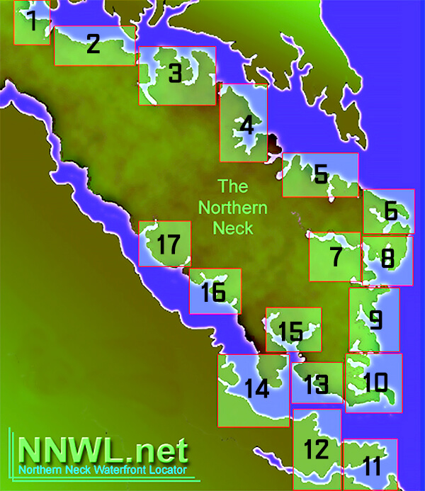
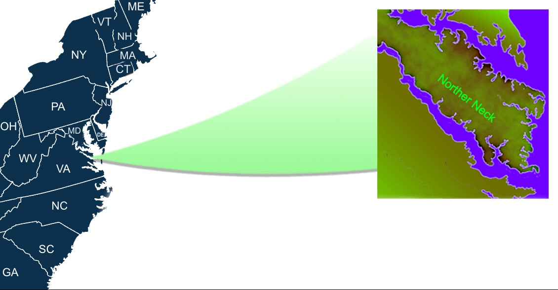
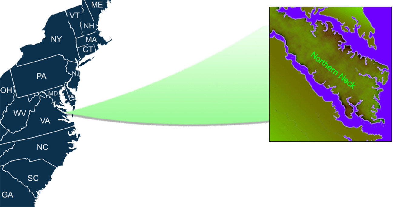
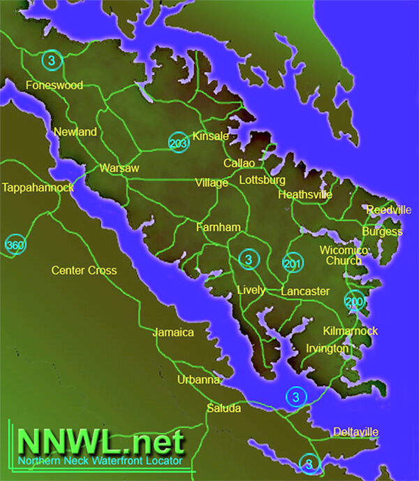
”Where’s
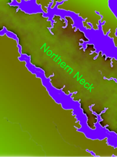
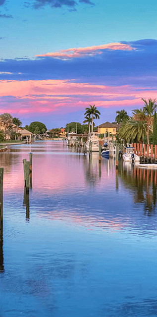
The Northern Neck of Virginia is a hidden gem for finding waterfront property. With its unique location between the Potomac and Rappahannock rivers, this area offers stunning views and unparalleled access to the water. Whether you’re looking for a quaint cottage or a luxurious estate, there are plenty of options to choose from. The region is known for its rich history, charming small towns, and abundance of outdoor activities such as boating, fishing, and kayaking. Plus, with its proximity to major cities like Washington D.C. and Richmond, you can enjoy the peacefulness of waterfront living without sacrificing convenience. Overall, finding waterfront property in the Northern Neck of Virginia is an opportunity to experience a truly special way of life.
”The
Lorem Ipsum is simply dummy text of the printing and typesetting industry. Lorem Ipsum has been the industry’s standard dummy text ever since the 1500s, when an unknown printer took a galley of type and scrambled it to make a type specimen book.
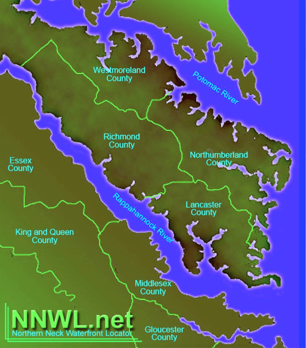
-
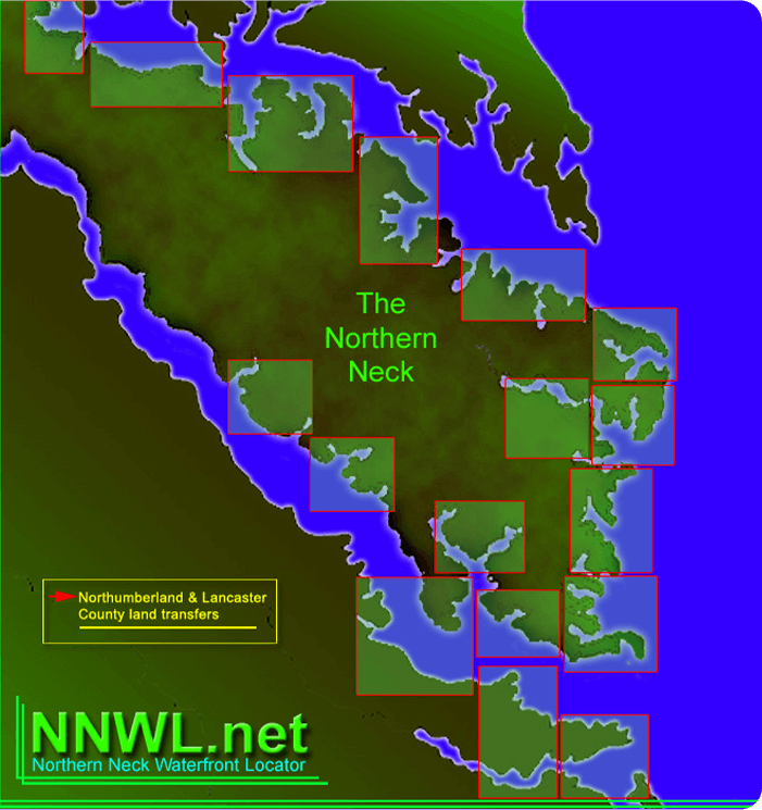
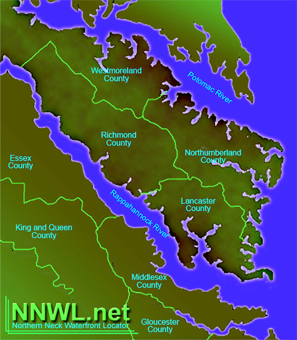
Lancaster County
-
Northumberland County
-
Richmond County
-
Westmoreland County
-
Gloucester County
-
Middlesex County
-
King & Queen County
-
Essex County
Land Transfers
”Lancaster
-
January 2024
-
February 2024
-
March 2024
-
April 2024
-
May 2024
-
June 2024
-
July 2024
-
August 2024
-
October 2024
-
November 2024
-
December 2024
”Northumberland
-
January 2024
-
February 2024
-
March 2024
-
April 2024
-
May 2024
-
June 2024
-
July 2024
-
August 2024
-
October 2024
-
November 2024
-
December 2024
”Lancaster
-
January 2023
-
February 2023
-
March 2023
-
April 2023
-
May 2023
-
June 2023
-
July 2023
-
August 2023
-
October 2023
-
November 2023
-
December 2023
”Northumberland
-
January 2023
-
February 2023
-
March 2023
-
April 2023
-
May 2023
-
June 2023
-
July 2023
-
August 2023
-
October 2023
-
November 2023
-
December 2023
”Lancaster
-
January 2022
-
February 2022
-
March 2022
-
April 2022
-
May 2022
-
June 2022
-
July 2022
-
August 2022
-
October 2022
-
November 2022
-
December 2022
”Northumberland
-
January 2022
-
February 2022
-
March 2022
-
April 2022
-
May 2022
-
June 2022
-
July 2022
-
August 2022
-
October 2022
-
November 2022
-
December 2022
”Lancaster
-
January 2021
-
February 2021
-
March 2021
-
April 2021
-
May 2021
-
June 2021
-
July 2021
-
August 2021
-
October 2021
-
November 2021
-
December 2021
”Northumberland
-
January 2021
-
February 2021
-
March 2021
-
April 2021
-
May 2021
-
June 2021
-
July 2021
-
August 2021
-
October 2021
-
November 2021
-
December 2021
Local News
\u0441hicken road game casino 8
\r
Chicken Road mixes elements of the puzzles with slots to cater to a broader audience …
Behavioral Patterns in Current Digital Engagement
Digital systems record millions of user behaviors daily. These behaviors expose unif…
Cognitive bias in interactive framework architecture
Interactive frameworks form everyday experiences of millions of users worldwide. …
Cognitive bias in dynamic framework architecture
Dynamic platforms influence daily interactions of millions of users worldwide. Creato…
Cultura urbana e spazi di divertimento nel XIX secolo
Il diciannovesimo secolo simboleggi\u00f2 un periodo di sostanziali modifiche per le …
Cultura urbana e spazi di svago nel XIX secolo
Il diciannovesimo secolo simboleggi\u00f2 un momento di profonde cambiamenti per le metropol…
Il compito delle mercati storiche nelle attivit\u00e0 divertenti
Le fiere storiche costituivano istanti cruciali per la vita ricreativa del…
Costruzione grandiosa destinata al tempo disponibile in Italia
L’Italia preserva un ricchezza eccezionale di strutture costruttive dis…
Edilizia imponente riservata al momento disponibile in Italia
L’Italia custodisce un tesoro notevole di costruzioni costruttive ideate…
Costruzione monumentale destinata al periodo ozioso in Italia
L’Italia mantiene un patrimonio eccezionale di costruzioni costruttive i…
Edilizia grandiosa destinata al periodo ozioso in Italia
L’Italia conserva un patrimonio eccellente di complessi architettoniche diseg…
Cultura urbana e posti di svago nel XIX secolo
Il diciannovesimo secolo costitu\u00ec un periodo di profonde mutamenti per le centri europe…
”Where
”#4″
The Northern Neck of Virginia is a hidden gem for finding waterfront property. With its unique location between the Potomac and Rappahannock rivers, this area offers stunning views and unparalleled access to the water. Whether you’re looking for a quaint cottage or a luxurious estate, there are plenty of options to choose from. The region is known for its rich history, charming small towns, and abundance of outdoor activities such as boating, fishing, and kayaking. Plus, with its proximity to major cities like Washington D.C. and Richmond, you can enjoy the peacefulness of waterfront living without sacrificing convenience. Overall, finding waterfront property in the Northern Neck of Virginia is an opportunity to experience a truly special way of life.
”Where
The Northern Neck of Virginia is a hidden gem for finding waterfront property. With its unique location between the Potomac and Rappahannock rivers, this area offers stunning views and unparalleled access to the water. Whether you’re looking for a quaint cottage or a luxurious estate, there are plenty of options to choose from. The region is known for its rich history, charming small towns, and abundance of outdoor activities such as boating, fishing, and kayaking. Plus, with its proximity to major cities like Washington D.C. and Richmond, you can enjoy the peacefulness of waterfront living without sacrificing convenience. Overall, finding waterfront property in the Northern Neck of Virginia is an opportunity to experience a truly special way of life.
”These
”#5″
”These